Exquisite Eratosthenes

Eratosthenes and environs

Eratosthenes and environs
Sketch and Details by Richard Handy

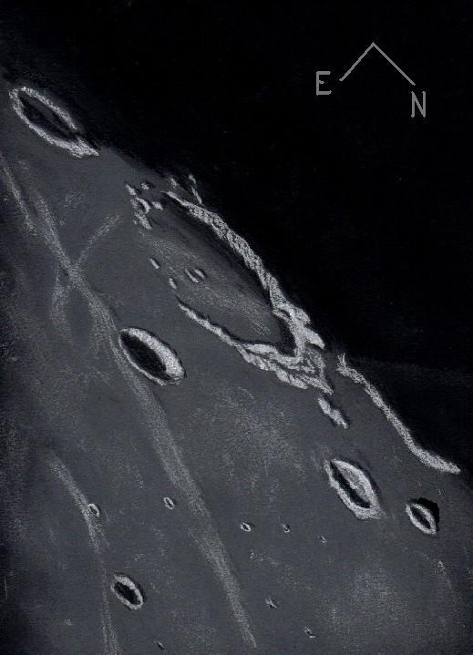
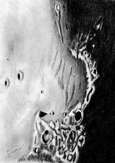
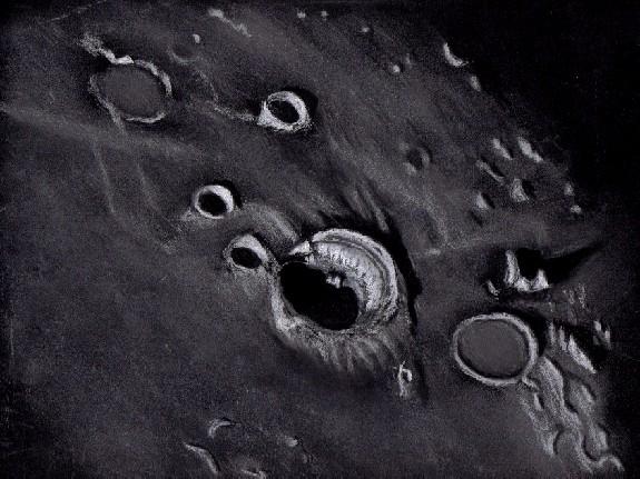
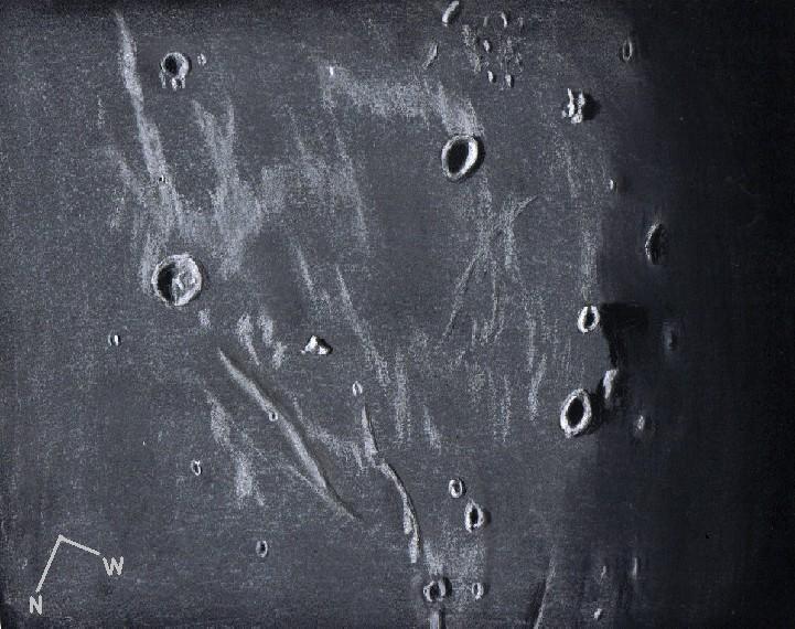
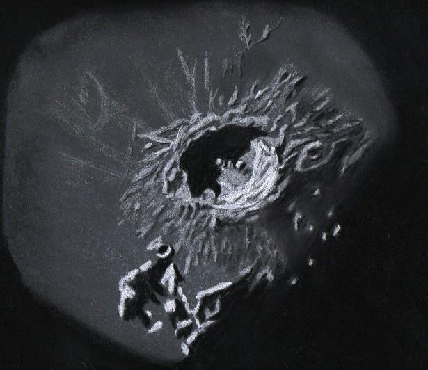
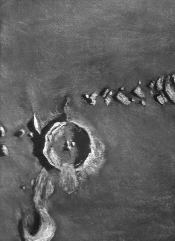
Description: Eratosthenes is the exquisite jewel sitting next to the Hope Diamond of Lady Luna, Copernicus. Consequently, Eratosthenes is often overshadowed by the spectacle of this lunar Juggernaut, however this sparkling gem of a crater and its immediate environment convey some of the major events that dominated the northwestern quadrant of the Moon. From 4.5 billion to 4.2 Billion years ago, a few hundred million years before the period of Heavy Bombardment, the large impactor Gargantuan, first proposed by the British geologist Peter Cadogan, struck the Moon with a force and fury far beyond our comprehension. The possibility that this impact could have, in one single event, reshaped the mean crustal thickness on both sides of the Moon is a staggering thought. Fed by fissures and cracks in the broken crust created by the force of the impact, magmas found easy passage to the basin floor. Over the intervening eons, the great basin formed by that event would eventually fill in with mare lavas to form Oceanus Procellarum. About 3.85 billion years ago, during the period of Late Heavy bombardment (3.8-4.0 by ago) the Moon received another enormous blow to this same northwest quadrant. The impactor, though half the size, formed another great basin, again flooding with mare lavas like Procellarum, to become the beautiful Mare Imbrium. To the east of Eratosthenes, the arcuate sweep of the Montes Apenninus, part of the remnant rim of giant Imbrium, seem to diminish to a few low outcrops as they approach the crater, probably appearing much like a mesa would if you were strolling on the surface. There are a few of these buried massifs on Eratosthenes’ northwestern flanks, although the great circular mountain range disappears in this region only to reappear as the Montes Carpatus to the northwest of Copernicus. There is a wonderful flame-like mountainous formation to the southwest of Eratosthenes, it appears to have been shaped by the fluidized flow fronts from the Imbrium event. Both Copernicus and Eratosthenes are benchmark features, meaning their formations correspond to the beginning of a geological period. Fifty-eight kilometer Eratosthenes was excavated by a 3 km wide impactor some 3.2 billion years ago. It’s rugged walls and terraces show significant scalloping and craterlet battering. The mare around Eratosthenes seemed coated in rays from 93 km Copernicus, which formed 1.1 billion years ago by an impactor 4.5 km in diameter, inaugurating the Copernican period. During this last 1000 million years most complex plant and animal life on Earth evolved.

Sketch details:
Subject: Eratosthenes and environs
Date: 12-28-2006 Start 5:27 UT End 6:50 UT
Lunation: 8.64 days Phase: 68.6 deg Colongitude: 19.8 deg
Illumination: 68.2 % Lib in Lat: -03 deg 24 min Lib in Long.: +01 deg 36 min
Seeing: Terrible most of the session, Antoniadi IV-V, only very occasionally III
Weather: clear
Telescope: 12” Meade SCT f/10
Barlow: 2X Televue
Binoviewer: Williams Optics Bino-P with 1.6X nosepiece
Eyepieces: 20 mm W.O. Plossls
Magnification: 396X
Sketch Medium: White and black Conte’ Crayon on textured black Strathmore paper
Sketch size: 18”x 24”

Eddington: A Mere Shadow of its Former Self

Eddington

Eddington
Sketch and Details by Frank McCabe

I was disappointed with my previous observation of this region of the Ocean of Storms this past August and this night was my first opportunity to return to this area. On this evening of observing and sketching, 137 kilometer, walled-plain crater remnant Eddington was well positioned and illuminated in the morning sunlight for drawing. The features that identify Eddington as a large crater ruin include the missing southern and eastern rims and the vast flooding of its floor with the mare lavas. Eddington is a Pre-Nectarian period crater which is likely older than 4 billion years. Today its worn appearance still has character. There is a broken arc of rim remains from south to east which gradually climbs from hills to mountains as the rim arc is traced northward. It may no longer be a regal crater, but it makes an excellent bay to the shore of the Ocean of Storms. To the east-southeast of Eddington rests the much younger Eratosthenian period crater Seleucus (44 km.). This is a deep crater at 3 km. and has a bright meandering debris ray from the crater Oblers A (not seen) passing the crater to the east. The Soviet moon probe Luna 13 landed 75 kilometers southeast of this crater. South along the terminator is the crater Krafft (51 km.) which makes an interesting partner to crater Cardanus beyond the sketching region to the south. Two craters are visible north and east of Eddington. These craters are Briggs (37 km.) and Briggs B (25 km.). Both were showing dazzling rims and ramparts in the early sunlight. The lone crater visible across the sketch to the northeast is Imbrian period crater Schiaparelli at 24 kilometers in diameter. This was that perfect lighting I was waiting for to capture this little corner of the Ocean of Storms.

Sketching:

For this sketch I used: black Strathmore 400 Artagain paper, white and black Conte’

pastel pencils and a blending stump. After scanning, Brightness was slightly decreased (-3) and contrast increased (+3) using Microsoft Office Picture Manager.

Telescope: 10 inch f/ 5.7 Dobsonian and 9 mm eyepiece 161x

Date: 6-17-2008, 2:55-3:50 UT

Temperature: 19° C (67° F)

Clear, transparent, calm

Seeing: Antoniadi III

Colongitude 72.7 °

Lunation 13.4 days

Illumination 98 %

Frank McCabe

Rainbow Bay

Bay of Rainbows

Sinus Iridum
Sketch and Details by Frank McCabe

Sinus Iridum (Bay of Rainbows) is one of the more attractive impact regions of the lunar moonscape under grazing illumination. The northern and western rim of this impact basin is composed of the rugged Jura mountain range from Cape LaPlace in the northeast to Cape Heraclides (the Moon Maiden) to the west. The bay reaches across a central distance of 260 kilometers. The entire southern portion of the crater rim is not seen for it is covered by the Mare Imbrium lava flows. First the massive impact that created Mare Imbrium about 3.8 billion years ago occurred. That event was followed by the smaller basin creating impact that left the large “crater Iridium” and subsequent events that buried its southern rim under lava flows some 3.3 billion years ago. Some geologists have suggested a seismic event before the lava flows aided in lowering the southern rim (see C.A Wood, The Modern Moon, p. 37).

One of the first sketches featuring Sinus Iridium in a telescopic view was done by Giovanni Cassini in 1679. In his drawing the Moon Maiden is featured. In my drawing Promontorium Heraclides (Moon Maiden) is seen at the upper right. Beyond this cape is a frozen wave of lava known as Dorsum Hein at the top center of the sketch. Following the arc of the sunlit Jura range, your eye arrives at the large shadowed floor of crater Bianchini (39km.) just beyond the half way point to Promontorium LaPlace (Cape LaPlace). Note the slumping of rim debris out into the bay from crater Bianchini. On to Cape LaPlace there is a tall mastiff at the cape that is casting a large triangular shadow that created a pleasing and eye catching view at the telescope ocular. Out beyond the reaches of the Bay of Rainbows are a pair of 20 km. diameter craters; Le Verrier is the slightly smaller one on the left and the other one is Helicon. This is a fascinating region of the moon to explore with a telescope and great fun to try and capture on paper.

Sketching

For this sketch I used: White CPP sketching paper, 9”x 12”, Numbers 2H, B and 4B graphite pencils, a blending stump, plastic eraser and an eraser shield. After scanning, Brightness was slightly decreased (-3) and contrast increased (+3) using Microsoft Office Picture Manager.

Telescope: 10 inch f/ 5.7 Dobsonian and 9mm eyepiece 161x
Date: 6-14-2008 1:30 – 2:42 UT
Temperature: 24° C (77° F)
clear, breezy
Seeing: Antoniadi IV
Co-longitude: 34.9°
Lunation: 10.26 days
Illumination: 81.5 %
Phase: 50.9°
Observing Location: +41°37′ +87° 47′

Frank McCabe

Upon the Sea of Clouds

Bullialdus

Bullialdus Crater
Sketch and Details by Frank McCabe

Western Mare Nubium has been the home of complex, Eratosthenian period crater Bullialdus (61 km.) for the past three and a half billion years. The beautifully terraced inner walls to the east and kilometer high central peaks were clearly seen in the morning light. The outer downward sloping walls were showing alternating radial ridges and valleys down to the lava flooded floor of Nubium. The crater rim stands 2.4 kilometers above the crater floor and the floor is 1.2 kilometers below the surrounding Mare Nubium lava.
The ancient flow of lava across the Sea of Clouds breached the walls and flooded the floors of craters Kies (44 km.) to the southeast and Lubiniezky (44 km.) to the northwest of Bullialdus. Immediately to the south of Bullialdus are Bullialdus A and B, both twenty something kilometers in diameter with the closer A being the larger of the two. The famous 11 kilometer dome Kies л was clearly seen just to the west of crater Kies and to the northwest, crater König (23 km.) looked impressive with its dark shaded floor.

Sketching:

For this sketch I used: black Strathmore 400 Artagain paper, 9”x 12”, white and black Conte’pastel pencils and a blending stump. Brightness was slightly decreased (-3) and contrast increased (+2) after scanning using Microsoft Office Picture Manager.

Telescope: 10 inch f/ 5.7 Dobsonian and 6mm eyepiece 241x
Date: 5-15-2008 2:10 – 3:45 UT
Temperature: 8° C (46° F)
passing clouds, calm
Seeing: Antoniadi III
Co-longitude: 28.8°
Lunation: 9.6 days
Illumination: 78.5 %
Phase: 55.3°
Observing Location: +41°37′ +87° 47′

Frank McCabe

Raising Eyebrows on the Floor of Imbrium

Aristillus and Autolycus

Aristillus and Autolycus
Sketch and Details by Richard Handy

Sitting replendently on the the eastern margin of Mare Imbrium, 56 km Aristillus and 41 km Autolycus, brothers of Copernician age, are a startling sight in the late lunar afternoon sunshine. Hexagonal in appearance, Aristillus’s broad and radially splayed glacis dominates the mare surface in this region. It’s wide, brilliantly lit terraces apparently have evidenced some mass wasting since its creation a little over a billion years ago. Resting on the floor, some 3650 m deep, the glowing central peaks are roughly 900 meters high. Rays, some quite prominent, emanate from the crater’s center. To the northwest of Aristillus, swathes of darker mare may indicate areas not fully dusted by the ejecta from this massive impact, or perhaps ejecta excavated from deep within the extant mare is responsible for these low albedo areas. Approximately 60 km to the south, Autolycus’s glacial nimbus appears almost serene in comparison to the complex nature of Aristillus’s glacis. Half of the floor of Autolycus is composed of quite torturous terrane including a strange floor subsidence to the eastern section of the floor.

Here are the sketch details:

Subject: Aristillus and Autolycus Rukl: 12
Date: 10-13-06 Start: 9:15 UT End: 10:50 UT
Lunation: 20.90 days Phase: 277.5 deg Illumination: 56.5%
Colongitude: 164.8 deg Lib. in Lat.: -5 deg 40 min Lib. in Long.: +7 deg 39 min
Seeing: Antoniadi III-IV with 30 seconds of Ant. II every 20 minutes
Weather: Clear early, turning to occasional clouds mid to late during session, 10-15 knot winds late.
Telescope: 12″ Meade SCT F10
Binoviewer: W.O. Bino-P with 1.6X Nosepiece.
Eyepieces: W.O. WA 20mm Plossls
Magnification: 244X
Lunation: 18.48 days Phase: 311.1 deg Illumination: 82.9%
Colongitude: 133.7 deg Lib in Lat.: -3 deg 53 min Lib in Long.: +5 deg 12 min
Sketch medium: White and black Conte’ Crayons on black textured Strathmore paper.
Sketch size: 18″ x 24″

A Lunie 4th: Lambert, Lambert R, Pytheas and Draper

Lambert and Environs

Lambert, Lambert R, Pytheas and Draper
Sketch and Details by Richard Handy

Last night about 9:15 pm PST, while the lingering smoke from the local fireworks were still wafting through the evening sky, I decided to try my first sketch through a new binoviewer I had just purchased. I had previously decided to try a target on the mare adjacent to the terminator because I wanted to see if the binoviewer would allow me less eye strain and greater acuity when it came to judging very fine tones of surface albedo.

When I actually started viewing my eyes were instantly drawn to the quiet spectacle of Lambert, Lambert R, Pytheas and Draper on the wide expanse of Mare Imbrium. Just to the south of Lambert, a 30 Km Eratosthenian crater with terraced walls, lay Lambert R, a ghostly ring barely visible even in the grazing light near the terminator, it’s sunken ramparts in ancient times swallowed by hot Imbrium lavas. Further along to the south, the 10 Km Pytheas seems to ride a wrinkle ridge that extends down to 8.8 Km Draper and Draper C.

The entire area of the the mare to the right of the terminator could have used a little more attention. Though I wanted to spend a little more time studying this area prior to the sketch, the Moon and my neighborhood Eucalyptus trees have a thing for each other I guess! : lol : So around 10:45 PDT when the Moon starting playing hide and go seek with me I ended my session.

Here are the details:

Date: 7-4-06
Time Started: 9:34pm PDT
Time Ended: 10:47pm PDT
Seeing: Antoniadi III-IV
Weather: Clear with some smoke from the fireworks
Telescope: 12″ Meade SCT f/10
Binoviewer: WO-Bino-P (1.6X) nosepiece
Eyepieces: WO WA 20mm Plossls
Magnification: 243X
Lunation: 9.52 days
Phase 72.3 degrees
Features: Lambert, Lambert R, Pytheas and Draper
Medium: White and black Conte’ Crayons on black textured Strathmore paper.
Sketch size: 18″ x 24″

Across the Largest Lunar Lava Plain

Mare Imbrium

Mare Imbrium
Sketch and Details by Frank McCabe

Ray debris from crater Copernicus can be seen cast across this distant region of Mare Imbrium.
The first crater visible to the southeast (upper left) is 20 kilometer Pytheas. Like many of the craters in this part of the lava covered floor, it is from the Eratosthenian period and unlike the younger Copernican period craters does not display fresh crater rays. Northward the largest crater in this sketch is Lambert (30 km.). The inner wall terraces as well as the central craterlet were visible but the buried ghost crater Lambert R was not seen to the south with the higher sun angle here. To the west of Lambert the pair of bright spots is mons La Hire a solitary lunar mountain and remnant of the lunar highlands not covered over by lava. North of mons La Hire and projecting straight to the northwest is Dorsum Zirkel a wrinkled ridge of 200 kilometers length. Another shorter ridge to the northwest is Dorsum Heim which arcs to the northeast of crater Caroline Herschel (14 km.). The crater to the west of Pytheas and Lambert is Euler a 28 kilometer shadowed floor cavity with a brightly illuminated inner wall on the western side. Beyond this crater to the west southwest is the irregular, complex mountain feature mons Vinogradov an old Imbrian feature. On to the north northwest along the terminator are craters Diophantus (19 km.) and Delisle (25km.) with mons Delisle in between and closer to the crater of the same name. A dorsum or ridge or perhaps a buried crater rim creates a sharp curving demarcation between illumination and darkness along the terminator.
I would have preferred to use higher magnification during this observation but the wind was gusty and making observation a challenge.

Sketching:

For this sketch I used: black Strathmore 400 Artagain paper, 8”x 11”, white and black Conte’pastel pencils and a blending stump. Brightness was slightly decreased (-2) and contrast increased (+3) after scanning using Microsoft Office Picture Manager.

Telescope: 10 inch f/5.7 Dobsonian and 12mm eyepiece 121x
Date: 4-16-2008 3:36 – 4:15 UT
Temperature: 9°C (48°F)
clear, windy
Seeing: Antoniadi III
Co longitude: 35.4°
Lunation: 10 days
Illumination: 82.9 %
Phase: 48.8°
Observing Location: +41°37′ .. +87° 47′

Frank McCabe

Raised, Tilted and polygonal

Aristarchus Plateau

The Aristarchus Plateau
By Frank McCabe

The Aristarchus Plateau
  
  The 3.6 billion year old Aristarchus plateau is a raised, tilted polygonal block
of crust in the ocean of storms with a collection of interesting features that can
be seen with telescopes of all sizes. Crater Aristarchus left of center is a large
(41 km.) 3.2 km. deep crater that is bright, young (500 million years old) and
sits near the SE edge of the plateau.  Lunar Prospector spacecraft back in 1998-99
detected radon gas being released from this region. The Space Telescope Science
Institute along with Northwestern University and others conducted an ultraviolet
and visible light analysis using the Hubble telescope to detect the presence of
titanium oxide near crater Aristarchus. This could be a potential source of oxygen
on the lunar surface and also a source of titanium metal.
   I remember well my disappointment when Apollo 18, 19 and 20 were cancelled in
1970. Apollo 18 was scheduled to land on the Aristarchus plateau near Schroter
valley. Schroter valley is an old Imbrium (3.5 billion years old) volcanic
feature that begins at the famous cobra head 25 km. north of ancient crater
Herodotus. This feature meanders north then west then southwest for more than 150
km. The bend is nearly 170 degrees. It is also large enough to be seen in a 2
inch telescope under conditions of good seeing.
  The region surrounding the beginning of Schroter valley was carefully imaged March
3rd and April 27th in 1994 by Clementine spacecraft because of reported color
changes. Clementine confirmed these changes were real. This region of the moon
shows color visible to some observers. It is described as reddish or yellowish by
those that can see this color.
  Don’t think of the moon as an annoyance that spoils galaxy hunting as some deep
sky enthusiasts sometimes do, but embrace it as the beautiful satellite it is,
awaiting observation and exploration.  
  
  
  Sketch:
  Graphite pencil, pen and ink sketch on copy paper 8.5”x11”
  Date: 1-2-2007 1:50 to 3:45 UT
  Temperature: -1.2 °C (30° F)
  Calm, seeing good for this part of Illinois
  Antoniadi mostly IV briefly III
  13.1 inch f / 5.9 Dobsonian 6mm ortho ocular 327X
  Colongitude: 66.8°
  Lunation: 12.5 days
  Illumination: 97%
  

Majestic Copernicus Crater

Copernicus

Lunar Crater Copernicus
By Frank McCabe

Across the Carpathian Mountains resting on the eastern Ocean of Storms is the
landmark crater of the Sea of Islands, mighty Copernicus. Copernicus is a 95
kilometer diameter complex crater that begins to show itself in all its majesty
two days past first quarter. During the time of “Snow-ball Earth” 800 million
years ago the event that created Copernicus suddenly occurred. What remains is a
3.8 kilometer deep hummock covered flat floored, centrally peaked, terrace walled
spectacular sentinel. Especially during high sun the bright ray system of this
crater can be seen extending from the base of the glassy glacis in all directions.
The descent from the rampart to the mare floor below is about one kilometer. Three
of five peaks were clearly visible in morning sunlight. In 1999 the Clementine
near infrared camera detected magnesium iron silicates in the peaks indicating
rebound of this deep rock through the surface crust following the impact event.
  To view this impressive crater all you need is a good pair of binoculars and an
opportunity between two days past first quarter and one day past last quarter.
Weather permitting you can see it tonight.
  
  Sketching:

For this sketch I used: black Strathmore 400 Artagain paper, 9”x 12”, white and
black Conte’pastel pencils and a blending stump. Brightness was slightly decreased
and contrast increased after scanning using Microsoft Office Picture Manager.

Telescope: 10 inch f/5.7 Dobsonian and 6mm eyepiece 241x
Date: 2-16-2008  8:45 – 10:50 UT (actual sketching time was 60min.)
Temperature: -10°C (14°F)
clear, calm
Seeing:   Antoniadi III
Co longitude: 24°
Lunation: 9 days
Illumination: 71.9 %
  Phase:   64°

Frank McCabe

Sunken Yet Uplifted

Lunar crater Posidonius

The lunar crater Posidonius
By Frank McCabe

Posidonius on the Eastern Shore of the Sea of Serenity
  
  On this cold morning in early December the most eye-catching crater resting on the
concave sloping rim of Mare Serenitatis was 96 kilometer diameter Posidonius. The
Posidonius cratering event likely occurred 150 thousand years or more after
Serenitatis formed a ring basin. The subsequent floor uplift and fracturing within
Posidonius created a large angular block and ridge margin that you can see arching
parallel along and just inside the outer eastern crater rim. At 17.5 days into the
lunation, the floor of Posidonius appeared much brighter than the dark margin lava
of Serenity. Eleven kilometer crater A near the center of Posidinius was clearly
visible in the poor seeing as were craters B, J, and M arching out from the rim to
the north. Beyond these craters encircled  by the Lake of Dreams is 25 by 30 km.
oval “island crater” Daniell, formed by a shallow angle impact before the greater
Posidonius event took place. South from Posidonius and again along the shore of
Serenity is the 63 km. flooded crater LeMonnier. Nearly all of the west rim of this
tilted crater and its floor are covered by the dark margin lava of the Sea of
Serenity.
  
  Sketching:
  
  2H graphite pencil on 5 x 8 inch index card
  Date: 12-8-2006 11:30 to 12:15 UT
  Temperature: -14 °C (6° F)
  clear, cold winds
  Pickering scale: 3/10
  10 inch f / 5.7 Dobsonian  161X
  Colongitude:127.5°
  Lunation: 17.6 days
  Illumination: 86.3 %         
  
  Frank McCabe