Crater Goclenius

Crater Goclenius
Crater Goclenius

The seeing was better than usual on November 18th, so I decided to use a high magnification on my C6, and see what would catch my eye.

Near the edge of Mare Fecunditatis, craters Gutenberg and Goclenius stood out, with two rimae running in from the north west.

I zeroed in on the crater Goclenius itself. The Rimae run right into it. The shadows were quite stark, revealing the broken down crater walls, and the fractures on the floor were very apparent.

A pencil sketch was done at the eyepice, and a photo taken. The final sketch was then completed at leisure a couple of weeks later.

Details:
Crater Goclenius, C6 (150mm SCT, 3 x Barlow)
Adelaide, South Australia, November 18th 2012.
Medium is charcoal on white paper.

-Ivan

Rima G. Bond

Rima G. Bond and Crater Hall

Hello,

today, when I started my observing-session, I found a very nice area with a longer Rima in south of Lacus Somniorum. It was the landscape near Crater Hall and G. Bond.

I´ ve never observed this region before and I was very surprised about the dark thin cleft, wich follows a course roughly along a north-south orientation, and continues for a length of about 150 kilometers.

Object Name Rima G. Bond / Crater Hall Object Type Lunar Crater Location near Tauberbischofsheim Germany Date 27.03.2012 20.30 – 21.00 p. m. Media graphite pencil and white Paper

The telescope was a Meade ACF 10″ on Vixen SXD by 300x

Best greetings

Uwe

Vallis Schröteri

Vallis Schröteri
Vallis Schröteri

Object name: vallisschröteri
Object type: Lunar Crater
Location: Amsterdam
Date: 8-5-2012
Media: Pastel on black paper

During a very gray period the last weeks, and with no chance to use the telescope, I decided to enhance my sketching skills by sketching some moon craters based on pictures made by others. This one is a sketch of the vallisschröteri area. Made with pastel pencil on black paper.

Clear skies and kind regards

Matthijs Broggel

Aristarchus, Herodotus and Schroter’s Valley

Aristarchus, Herodotus & Schroter's Valley

Objects names: lunar craters Aristarchus, Herodotus and Schroter’s Valley
Objects: Craters, sinuous rille and wrinkle ridges.
Location: Teulon, Manitoba, Canada
Date January 5th, 2012 (7:00-8:30 CST)
Media: Graphite pencils, ink pens and some digital scrubbing on highlights to get brightness adjusted. Original sketch on white paper approx 5″ x 8″

Objects viewed through Celestron Ultima 8 SCT with binoviewer around 250x with fairly good seeing. The individual peaks near the terminator were especially bright. What really struck me were the two wrinkle ridges at the top and bottom that seem to end in craters (but not quite) I had difficulty sketching the brightness range so used a little help from Iphoto to get the highlights back to how I saw them. Because of the amount of objects included, the sketch took longer than usual and some shadow lengths from one end of the sketch to the other would reflect the time difference. Just catching all the turns in Schroter’s Valley is very time consuming. As it was, I still couldn’t capture all that I saw. This was a most intimidating region to sketch.

Rimae Run Through It

Object Name: Petavius
Object Type: Lunar Crater
Location: Bristol, UK
Date: 24th Oct 2010
Media (graphite pencil sketch at the scope and then digitized using graphics tablet and Photoshop)
I usually sketch in some detail at the scope (mainly HB and 2B). I then scanned the result into Photoshop and used a Bamboo Pen graphics tablet to remaster the sketch. The final sketch was then “blurred” a touch to simulate the actual view which is never as sharp as I would like to see!)

Observational data: I use a Nexstar 8SE teamed with a Hyperion 8-24 mm zoom. Most of the sketch was at the 8mm stop and was drawn in good seeing conditions. The moon was 17 days old. I could see the circular crater formation of Petavius situated on the South bank of Mare Fecunditatis. The steep slope was rugged and contained a few craterlets. Wrottersley could be seen in the North-West (with a central peak) while Hase and Snellius could also be seen in the South. The main feature was the central mountain inside Petavius and the Rimae that ran from this to the crater wall. Very distinctive at the angle observed. Otherwise the floor was pretty flat. To the north I could see lines running way from the crater rim. The shadow obscured most the the craters to the East.
Hope you enjoy,

Clear Skies

Chris Lee

Ruined But Not Gone

It’s good to have dark skies returning again here in the North and a new season to look forward to.

I’ve always admired survivors, and on the moon Janssen has to count as one of the best; like a old warship that has taken hit after hit but refuses to sink. It’s classed as Pre-Nectarian, along with Brenner to its North, making it as old as solar system craters get. Metius, Lockyer and Steinheil however are later (Nectarian), and Fabricius later still (Eratosthenian). As well as the fun of picking out the subtle shadows of the rim of Jansen, there’s a curved (branched) rille to trace cutting its floor, which is one of the only highland rilles. Fabricius has two parallel mountain ridges on its floor. One can’t but wonder at the powerful forces that shaped this part of the moon billions of years ago.

Date and Location: 27th August 2010, York, UK; 21.30-22.30 UT.

Medium: Graphite pencil on white paper, sketched at the eyepiece.

Instrument: Skywatcher skyliner 152mm f8 Dobsonian, 10mmm ep with x2 Barlow.

Artist: Peter Mayhew

A Collapsed Lava Tube

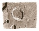
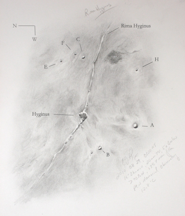
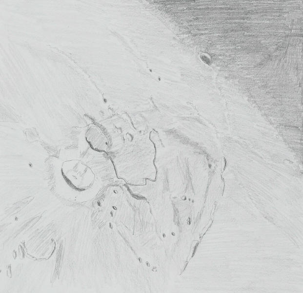
2010 08 29, 0820 UT Rima Hyginus
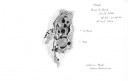
PCW Memorial Observatory, OH, USA, Erika Rix
Zhumell 16”, 20mm TV, 5x Barlow, 450x mag, 13% T moon filter
Temp: 12.8C, >90% humidity, S: Antoniadi I
Sketch created scopeside with Rite in the Rain paper and charcoal.

Phase: 307.3°
Lunation: 19.38d
Illumination: 80.3%
Lib. Lat: -6°04’
Lib. Long: -6°03’
Az: 260°08’, Alt: 34°57’

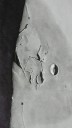
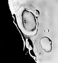
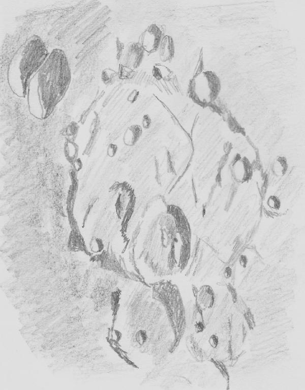
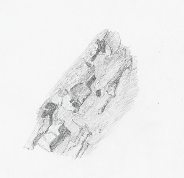
Rima Hyginus: Linear Rille, 7° E, 7.5° N
Imbrian period (-3.8 billion yrs to –3.2 billion yrs)
Dimension: ~226 km, Height: unknown
Named after Caius Julius Hyginus, 2nd century BC Greek Astronomer

http://www.lpod.org/archive/archive/2004/02/LPOD-2004-02-25.htm
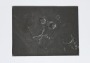
“The key to understanding the origin of Hyginus is probably the small
pit craters visible in the rille on the northwest (left) side of
Hyginus. These pits almost certainly formed by collapse of the roof over
a lava tube.”

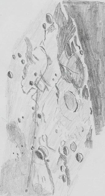
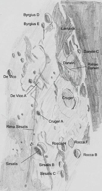
A lot of the features were washed out surrounding the rille, but the
flat floor of Hyginus was evident as well as its irregular shape. I
could make out some of the pits to the northwest half of the rille and a
couple hints of the craterlets (or pits) to the southeast half. The
subtle variances in albedo were difficult to render, however,
interesting to observe. If I remember correctly, the dark patch to the
north of H consists of volcanic ash.

While searching for information on this rille, I came across yet another
amazing image from Wes Higgins. The pits Chuck Wood wrote about in the
article above are clearly shown.
http://www.higginsandsons.com/astro/Pictures-iin-templets/Rima-Hyginus-08-03-07.htm

Resources
Rukl plate 34
“The Modern Moon” by C. Wood pgs. 58-59
LPOD:
http://www.lpod.org/coppermine/thumbnails.php?album=search&type=full&search=rima+hyginus

Erika Rix

On the plain at Hadley

Hadley Rille

Hadley Rille and Surroundings
By Peter Mayhew

For a lunar observer, seeking out the Apollo landing sites is an inevitable pilgrimage. The easiest, and most rewarding, site to locate is the Apollo 15 site at Hadley Rille on the edge of the Apennine mountains.

On the evening of 22nd April, the sky suddenly cleared just as I was about ready for bed, so I changed plans and took out the scope for a gaze at a crystal clear day 8 moon. Seeing was excellent, and lighting conditions were just right for picking out the Apollo 15 site features.

I tried hard to locate St George crater, which is on the tip of Mons Hadley Delta, was one of the Apollo 15 sampling site targets, and is visible in a small telescope, but I only got unsure brief suggestions of it; perhaps the sun angle wasn’t quite right for this. However I could see the rille itself easily, and several mountains and hills photographed by Scott and Irwin from the lunar surface, as well as Silver Spur, on the flank of Hadley Delta. The “x” marks the landing site.

For comparison, here are some links to photographs of these features taken from the surface.

Landing site panorama. Here Mons Hadley is on the left and Hadley Delta just right of centre.

Mons Hadley

Mons Hadley Delta

Silver Spur

Hadley Rille

Bennett Hill

Hill 305.

Object name: Hadley Rille, Mons Hadley, Mons Hadley Delta, Hadley C, Apollo 15 landing site.

Object type: Lunar rille, lunar crater, lunar mountains

Location: York, UK

Date: 22nd April 2010

Media: graphite pencil on white paper

Instrument: Skywatcher Skyliner 152mm f8 Dobsonian with 10mm e.p. and x2 Barlow.

Shield of confusion

Aristarchus Plateau

The Aristarchus plateau
Sketch and Details by Peter Mayhew
Hover cursor over sketch to view labels.

A lovely bright day 12 moon hung in the southern sky just before and after sunset. The terminator was just to the west of the Aristarchus plateau. Having saved and saved this for sketching for months, I gave in and did it. The clouds kept rolling across the moon interrupting me; first low thick stuff, and later high foggy stuff. But by 9.30pm I had got most of the visible features on paper. It wasn’t the best night for seeing, but was tolerable. The plateau is a volcanic shield about 200km square, in the North West of the Ocean of Storms. It breaks all sorts of lunar records; the brightest crater (Aristarchus), the longest sinuous rille (Vallis Schroteri), the most coloured spot “Wood’s spot” (the shield itself). Aristarchus itself appears bright white, especially the area to the east. Surrounding the ejecta slopes is a dark melt band, and then rays can be seen extending east, north and south. The crater itself has a central hill and a dark band surrounding that, as well as darker bands on the western crater wall. North-East is the ghost crater Prinz. Herodotus is an older, flooded crater, which seems on initial inspection to be the source of Schroter’s valley; the view is deceptive because of the notch in its northern wall and the dark surrounding land. The valley itself is sufficiently broad to distinguish either wall, and winds first north, then west and finally south, narrowing as it goes. The north-west of the shield is guarded by the long mountain chain Montes Agricola. Mons Herodotus lies to its south. The western area near the terminator is crossed by wrinkle ridges. The area is so complex that it was a real struggle to take in all the detail that was there: for this reason I’ve dubbed it the “shield of confusion”. I suspect another visit with better seeing conditions will bring out new features.

The sketch was graphite pencil on white paper, done at the eyepiece. Instrument: Skywatcher Skyliner 150mm f8 Dobsonian, 10mm e.p. plus x2 Barlow.

Rille with a Hook

Rille with a Hook

Rima Sirsalis
Sketch and Details by Peter Mayhew

Object Name: Rima Sirsalis
Object Type: Lunar Rille
Location: York, U.K.
Date: 31st October 2009
I used graphite pencil on white paper. My observing instrument was a
Skywatcher Skyliner 150mm f8 Dobsonian with a 10mm eyepiece and x2 Barlow.

Rille with a Hook

Labeled sketch of Rima Sirsalis
Sketch and Details by Peter Mayhew

I have just endured twenty days of grey cloud without sight of the
stars: it was almost unbearable. This came with unseasonal mild weather
for October for the UK. On 31st, there was a brief gap in the clouds at
20:00 UT and I got the scope out to look at the day 13 moon; I spent a
few minutes deciding whether to sketch Wargentin or Rima Sirsalis, and
as you can see decided on the latter. High cloud rolled in but I kept on
going, and managed a passable sketch in decreasing visibility as the sky
turned foggy. The terrain which the rille cuts through is fascinating;
from the Ocean of storms in the north (bottom) past craters Sirsalis and
Cruger A, and then on reaching De Vico A it makes a westward hook
towards Lamarck and Byrgius before petering out. The nearby craters
Darwin and Cruger make excellent background scenery. I include a
labelled version. The rille is 420km long and 5km wide.